


For Tropical North Atlantic Ocean, Caribbean Sea, and Gulf of Mexico
Area Of Special Interest: 10–20°N and 40–65°W
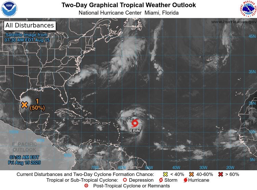
Tropical Storm Erin: At 8 am, the centre of Tropical Storm Erin was located near latitude 18.1°North, longitude 55.2°West. Erin is moving toward the west-northwest near 17 mph. This motion is expected to continue into the weekend. On the forecast track, the centre of Erin is likely to move near or just north of the northern Leeward Islands over the weekend. Maximum sustained winds are near 70 mph with higher gusts. Steady strengthening is expected during the next few days, and Erin is forecast to become a hurricane later today, and it could become a major hurricane by this weekend. Tropical-storm-force winds extend outward up to 90 miles mainly to the northeast of the centre. The latest minimum central pressure estimated from NOAA Hurricane Hunter aircraft data is 998 mb.
Disturbance (1): Shower and thunderstorm activity has persisted in association with a disturbance located about 75 miles off the coast of northeastern Mexico or southern Texas coastline. The system could become a short-lived tropical depression before it moves inland this afternoon or evening. Regardless of development, locally heavy rainfall is possible along portions of northeastern Mexico and southern Texas over the next couple of days, and interests there should monitor the progress of this system. Another Air Force Reserve Hurricane Hunter aircraft is scheduled to investigate the system later this morning. This system has a medium chance, 50%, of becoming a tropical cyclone within the next 48 hours.
The next update will be issued at 2 pm.
Meteorological Services, MBIA
Grenada Airports Authority (GAA)