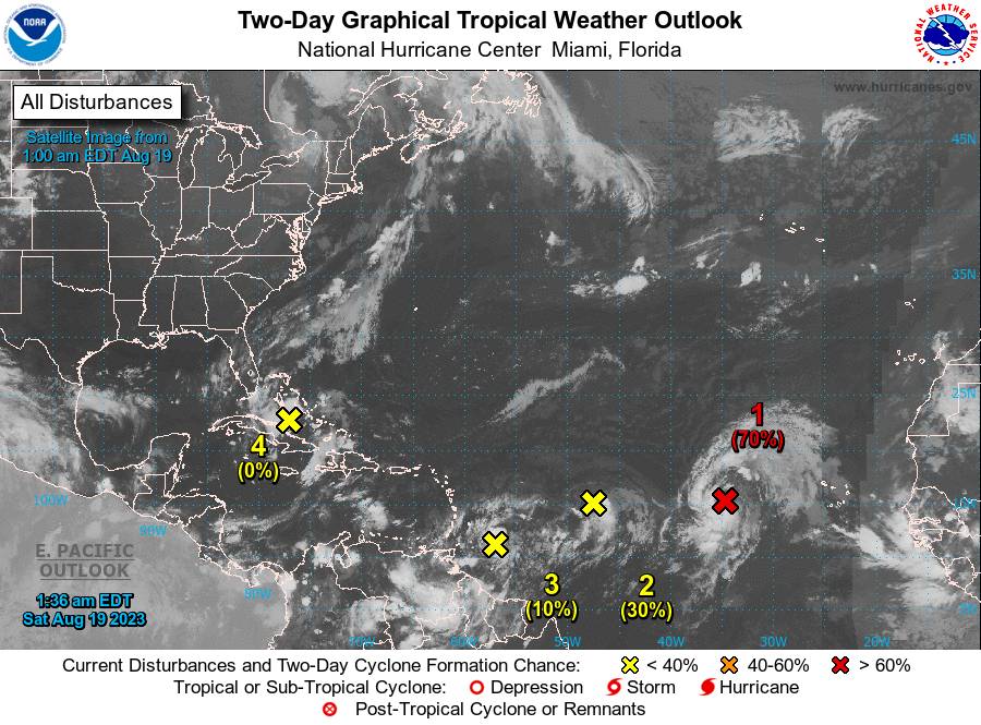


FOR TROPICAL NORTH ATLANTIC OCEAN, CARIBBEAN SEA, AND GULF OF MEXICO AREA OF SPECIAL INTEREST: 10 – 20°N AND 45 – 65°W
- Eastern Tropical Atlantic:
Showers and thunderstorms continue to show signs of organization in association with a broad area of low pressure located several hundred miles west of the Cabo Verde Islands. Environmental conditions appear generally favourable for further development of this system, and a short-lived tropical depression is likely to form this weekend while it moves west-northwestward or northwestward at about 10 mph across the eastern tropical Atlantic. By early next week, upper-level winds over the system are forecast to increase, and further development is not expected. Formation chance through 48 hours, high, 70%. This system poses no direct threat to the State of Grenada.
- Central Tropical Atlantic:
An area of low pressure located roughly halfway between the Cabo Verde Islands and the Lesser Antilles is producing limited showers and thunderstorms to the east of its centre. Environmental conditions are forecast to become increasingly unfavourable for further development of this system during the next day or two while it moves west-northwestward at 10 to 15 mph across the central tropical Atlantic. Formation chance through 48 hours, low, 30%. This system poses no direct threat to the State of Grenada.
- East-Southeast of the Lesser Antilles:
A tropical wave located a few hundred miles to the east-southeast of the Lesser Antilles is producing some disorganised showers and thunderstorms. Some gradual development of this system is possible this weekend and during the early and middle parts of next week while it moves westward to west-northwestward at 10 to 15 mph, across the Lesser Antilles and over the eastern and central Caribbean Sea. Formation chance through 48 hours, low, 10%. Regardless of its development, this system is expected to generate showery activity and thunderstorms over the State of Grenada over the weekend. The Met Office has issued a warning for a high chance of flash flooding and landslides for Saturday afternoon to Sunday.
- Western Gulf of Mexico:
An area of disturbed weather located near the northwestern and central Bahamas is expected to move into the Gulf of Mexico by early next week, where a broad area of low pressure is expected to form. Some slow development of this system is possible thereafter, and a tropical depression could form as it moves westward and approaches the western Gulf of Mexico coastline by the middle of next week. Formation chance through 48 hours, low, near 0%. This system poses no direct threat to the State of Grenada.
The Meteorological Office will continue to monitor these systems. The next update will be issued at 8 am.
Eugine Whint
Duty Forecaster