


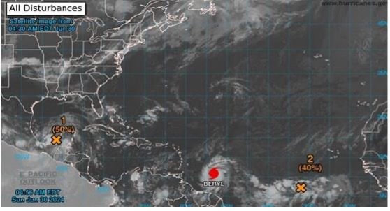
St George’s, Grenada — Sunday, 30 June 2024. 6:30 am
Grenada, Carriacou and Petite Martinique are currently under a Hurricane Warning.
At 5 am, the centre of Hurricane Beryl was located near latitude 10.7 °North, longitude 53.1 °West, about 500 nautical miles east-southeast of Grenada.
Beryl is moving toward the west near 21 mph (33 km/h). A continued quick westward to west-northwestward motion is expected during the next few days. On the forecast track, the centre of Beryl is expected to move across the Windward Islands early on Monday and across the southeastern Caribbean Sea on Monday night and Tuesday.
Maximum sustained winds have increased to near 100 mph (155 km/h) with higher gusts. Rapid strengthening is forecast over the next day or so, and Beryl is expected to become an extremely dangerous hurricane before it reaches the Windward Islands.
Hurricane-force winds extend outward up to 15 miles (30 km) from the centre, and tropical-storm-force winds extend outward up to 80 miles (130 km). The estimated minimum central pressure is 981 mb (28.97 inches).
Potential Impacts
Wind: Devastating wind damage is expected (early on Monday) where the eyewall of Beryl moves through the Windward Islands.
Seas: A life-threatening storm surge with water levels 6 to 9 feet above normal tide levels in areas of onshore flow near where Beryl makes landfall.
Rainfall: Rainfall totals of 75 to 150 millimetres across Barbados and the Windward Islands Sunday night into Monday. This rainfall may cause flooding in vulnerable areas.
Surf: Swells generated by Beryl are expected to reach the Windward and southern Leeward Islands by this evening.
The public is encouraged to follow the advisories and forecasts issued by the Meteorological Office and NaDMA.
For additional information, contact Ruth Jacob-Roberts, Public Information Officer at NaDMA 440-8390-4: cell 533-0766, or email: [email protected] and [email protected].
NaDMA is the official source for all disaster-related information in Grenada.


Hello, I am on Vacation in Grenada. I did not expect this. Thank you for caring.
Unscheduled 11:35AM update from the NOAA, the storm is now a Cat 4 hurricane with maximum sustained winds of 130mph (215 km/h) and central pressure of 962mb.
“…LIFE-THREATENING WINDS AND STORM SURGE EXPECTED IN THE WINDWARD
ISLANDS BEGINNING EARLY MONDAY MORNING…”
Best wishes to all of you from Florida