


For Tropical North Atlantic Ocean, Caribbean Sea, and Gulf of Mexico
Area Of Special Interest: 10–20°N and 40–65°W
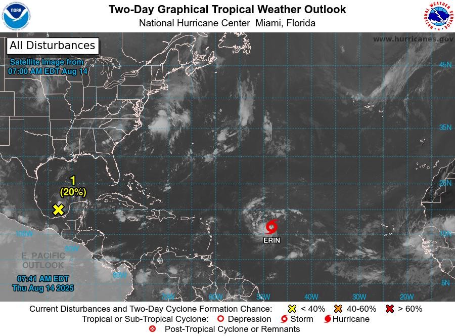
Tropical Wave: An eastern Caribbean tropical wave is along 65W, from the Virgin Islands southward into central Venezuela, moving westward at around 10 kt. No significant convection is noted near the wave axis.
Tropical Storm Erin: At 11 am, the centre of Tropical Storm Erin was located near latitude 16.4°North, longitude 49.7°West. Erin is moving toward the west near 17 mph. A turn toward west-northwest is expected tonight, with this motion expected to continue into the weekend. On the forecast track, the centre of Erin is likely to move near or just north of the northern Leeward Islands over the weekend. Maximum sustained winds have increased to near 60 mph with higher gusts. Additional strengthening is forecast during the next day or so, and Erin is expected to become a hurricane on Friday. Tropical storm-force winds extend outward up to 60 miles from the centre. The estimated minimum central pressure is 999 mb.
Disturbance (1): Shower and thunderstorm activity has increased in association with an area of low pressure located over the Bay of Campeche. The low is forecast to move west-northwestward across the southwestern Gulf during the next day or so, where environmental conditions are marginally conducive for further development. A tropical depression could form before this system moves inland over northeastern Mexico or southern Texas by late Friday, ending its chances for tropical development. Regardless of development, locally heavy rainfall is possible along portions of northeastern Mexico and southern Texas over the next few days. An Air Force Reserve Hurricane Hunter is en route to investigate this system. This system has a medium chance, 40%, of becoming a tropical cyclone within the next 48 hours.
The next update will be issued at 8 pm.
Meteorological Services, MBIA
Grenada Airports Authority (GAA)