


For Tropical North Atlantic Ocean, Caribbean Sea and Gulf of Mexico
AREA OF SPECIAL INTEREST: 10 – 20 °N AND 45 – 65 °W
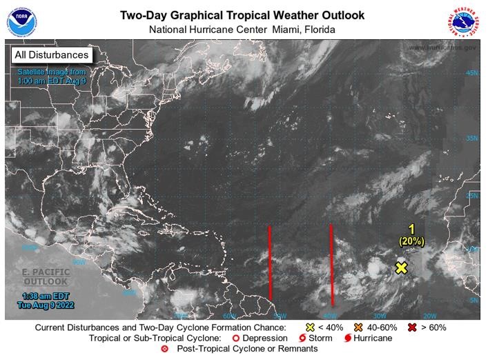
Tropical Wave #1
A central Atlantic tropical wave has its axis along 53°W, extending 02°N to 20°N, 453 nautical miles (nm) east of Grenada. It is moving westward at 15 kt. Scattered weak convection is observed from 12°N to 15°N, between 50°W and 55°W.
Based on its forward speed and model projections, the axis of this wave should traverse the island chain on Tuesday night into Wednesday morning, inducing cloudiness and showery activity with a low chance of lightning and thunder if environmental conditions remain favourable. The invasion of dry Saharan dust in the northern part of wave environment may reduce the likelihood of significant rainfall across the State of Grenada on Tuesday night and Wednesday.
Tropical Wave #2
A central Atlantic tropical wave has its axis along 40°W, extending 02°N to 20°N, 1260 nm east of Grenada. It is moving westward at 15 kt. Isolated moderate convection is observed from 13°N to 7°N, between 35°W and 39°W. Based on its forward speed and model projections, the axis of this wave should traverse the island chain on Thursday night into Friday morning. However, models signal that the most active weather will be steered further north of Grenada, across the Central Lesser Antilles. Nevertheless, there is a medium chance of occasional cloudiness and showery activity with a low chance of lightning and thunder on Friday if environmental conditions remain favourable.
Disturbance 1
A tropical wave continues to produce a large area of disorganised showers and thunderstorms over the eastern tropical Atlantic a few hundred miles south-southwest of the Cabo Verde Island. Environmental conditions appear generally conducive for gradual development of this system while it moves westward to west-northwestward at 15kt to 20kt across the eastern and central tropical Atlantic, and a tropical depression could form around the middle to latter part of this week. here is a low (20%) formation chance through 48 hours and a medium (40%) formation chance through 5 days.
The Meteorological Service will continue to monitor the progress of these systems and provide updates in a timely manner.
Elsewhere, tropical cyclone formation is not expected during the next 2 days.
The next update will be issued at 8 am.
Cécil Mitchell, Duty Forecaster