


FOR TROPICAL NORTH ATLANTIC OCEAN, CARIBBEAN SEA, AND GULF OF MEXICO AREA OF SPECIAL INTEREST: 10 – 20°N AND 45 – 65°W

Tropical Wave: A tropical wave is in the Atlantic along 53 °W, approximately 450 nautical miles east of Grenada, S of 17 °N, moving W at 10-15 kt. No significant convection is noted. Models suggest this wave is expected to cross the island chain Friday into Saturday, bringing an increase in cloud cover, showers and possible isolated thunder.
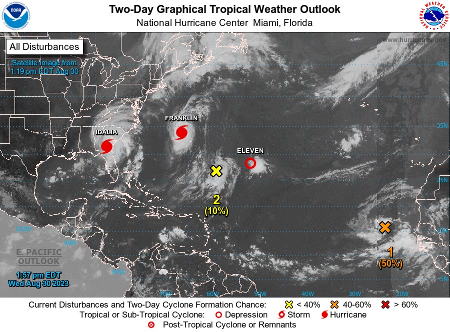
Eastern Tropical Atlantic (Orange): A broad area of low pressure associated with a tropical wave located near the Cabo Verde Islands is producing disorganised showers and thunderstorms. Environmental conditions appear conducive for gradual development of this system, and a tropical depression is likely to form later this week while the system moves west-northwestward to northwestward across the eastern tropical Atlantic. This system has a medium (50%) chance of development. This system currently poses no direct threat to Grenada.
Central Subtropical Atlantic (Yellow): Showers and thunderstorms associated with a trough of low pressure (the remnants of Gert) are located several hundred miles north of the northern Leeward Islands. Environmental conditions are becoming unfavourable for additional development as the system drifts northward or north-northeastward. This system has a low (10%) chance of development. This system currently poses no direct threat to Grenada.
Hurricane Franklin: At 2 pm AST (1800 UTC), the centre of Hurricane Franklin was located near latitude 33.9 °North, longitude 66.6 °West. Franklin is moving toward the northeast near 13 mph (20 km/h). A gradual turn toward the east-northeast is expected tonight, with a slightly faster east-northeastward motion through Friday. On the forecast track, the centre of Franklin is expected to pass to the northwest of Bermuda through this evening. Maximum sustained winds are near 105 mph (165 km/h) with higher gusts. Gradual weakening is forecast over the next several days. Hurricane-force winds extend outward up to 45 miles (75 km) from the centre and tropical storm-force winds extend outward up to 160 miles (260 km). An elevated weather station at the National Museum of Bermuda recently reported a sustained wind of 39 mph (63 km/h) and a gust of 62 mph (100 km/h). A weather station at the Bermuda airport recently reported a 2-minute average wind of 40 mph (65 km/h) and a gust of 50 mph (81 km/h). The estimated minimum central pressure is 961 mb (28.38 inches). This system currently poses no direct threat to Grenada.
Hurricane Idalia: At 2 pm, the centre of Hurricane Idalia was located by Doppler radar near latitude 31.4 °North, longitude 82.5 °West. Idalia is moving toward the northeast near 20 mph (31 km/h). A turn toward the east-northeast is expected tonight, followed by an eastward motion on Thursday. On the forecast track, the centre of Idalia will continue moving across southeastern Georgia through this evening, near the coast of South Carolina tonight, and just offshore the coast of southern North Carolina on Thursday. Idalia is then expected to move east southeastward over the western Atlantic on Friday. NOAA Doppler radar data indicate that maximum sustained winds have decreased to near 75 mph (120 km/h) with higher gusts. Idalia is forecast to weaken further, but it could still produce hurricane-force winds, especially in gusts, through this evening across portions of southeastern Georgia and southern South Carolina. Idalia is forecast to be a tropical storm while moving near the coasts of northeastern South Carolina and North Carolina tonight and on Thursday. Hurricane-force winds extend outward up to 25 miles (35 km) from the centre and tropical-storm-force winds extend outward up to 230 miles (370 km). The estimated minimum central pressure is 981 mb (28.97 inches). This system currently poses no direct threat to Grenada.
Tropical Depression 11: At 11 am, the centre of Tropical Depression Eleven was located near latitude 28.3 °North, longitude 52.1 °West. The depression is moving toward the north near 2 mph (4 km/h) and it will likely continue to meander slowly for the next day or so. A slightly faster northward motion is expected to begin in about a day. Maximum sustained winds are near 35 mph (55 km/h) with higher gusts. Little change in strength is forecast during the next day or so. The system is expected to become a remnant low within the next couple of days. The estimated minimum central pressure is 1014 mb (29.95 inches). This system currently poses no direct threat to Grenada.
The Meteorological Service will continue to monitor these systems and provide updates in a timely manner.
The next update will be issued at 8 pm.
Johnathan Pryce, Duty Forecaster