


FOR TROPICAL NORTH ATLANTIC OCEAN, CARIBBEAN SEA AND GULF OF MEXICO
AREA OF SPECIAL INTEREST: 10 – 20 °N AND 40 – 65 °W

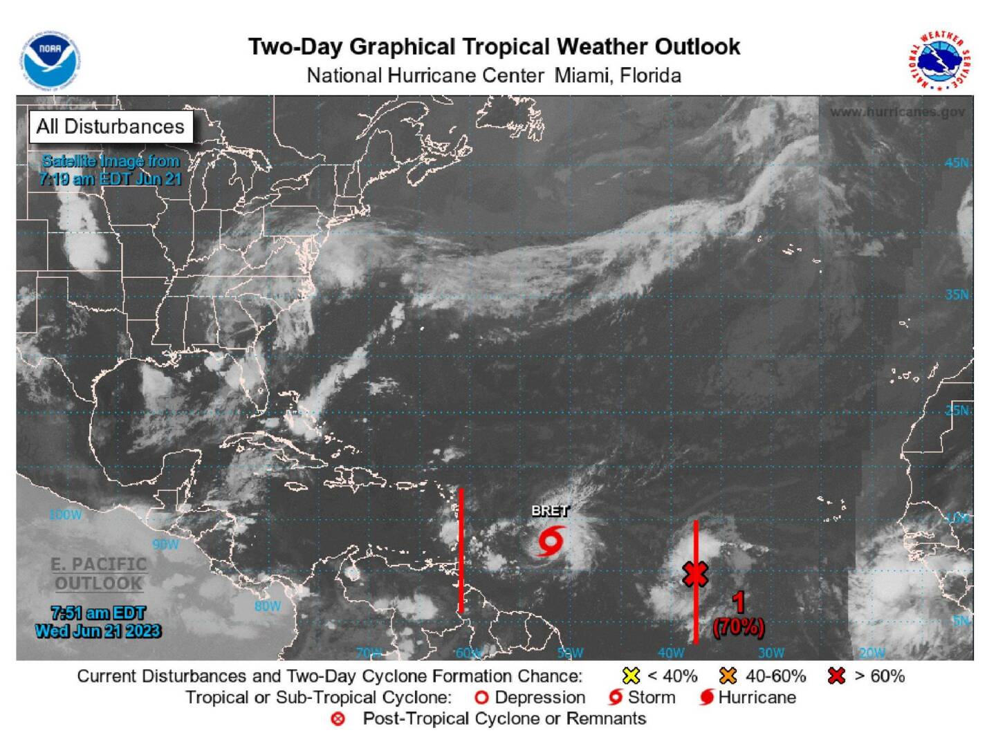
Tropical wave: A tropical wave extends along 61°W from 06°N to 18°N, moving west at around 10- 15 kt. Scattered showers are observed from 11°N to 17°N between 60°W and 63°W.
Tropical Storm Bret: At 5 am, Tropical Storm Bret was centred near 12.8°N 51.4°W or 560 nm E of the Windward Islands, moving W at 14 kt. Estimated minimum central pressure is 1001 mb. Maximum sustained wind speed is 50 kt with gusts to 60 kt. Seas 12 ft or greater are observed within 90 NM NE quadrant…45NM SE quadrant…30 NM SW quadrant…and 60 NM NW quadrant, with seas to 16 ft. Scattered to numerous moderate convection is noted from 10°N-16°N between 48°W-53°W.
Bret is expected to continue moving west for the next several days. On the forecast track, the centre of Bret is expected to move across portions of the Lesser Antilles Thursday afternoon and Thursday night and then move across the eastern Caribbean Sea on Friday. Through Saturday, storm total rainfall amounts of 3 to 6 inches with maximum amounts of 10 inches are possible across portions of the Lesser Antilles from Guadeloupe south to Grenada, including Barbados. The heavy rainfall could lead to flash flooding, especially across areas of higher terrain. Isolated urban flooding is also possible. A Tropical Storm Watch has been issued for Barbados, Dominica, Martinique, and St Lucia.
Please note: Grenada and its dependencies are NOT under a storm watch or warning.
Tropical wave: A tropical wave extends along 36°W from 03°N to 15°N, moving west at about 10- 15 kt. A 1011 mb low is analyzed along the wave near 10N37W. Scattered showers and thunderstorms are noted from 05°N-13°N between 35°W-42°W. Strong winds are noted in the northern semicircle of the low, where seas are in the 6-8 ft range. Environmental conditions appear conducive for further development of this system, and a tropical depression will likely form during the next couple of days while the system moves westward across the central tropical Atlantic. This wave has a high (70%) chance of tropical cyclone formation in the next 48 hours and a high (80%) chance over the next 7 days.
The Meteorological Service will continue to monitor these systems and provide updates in a timely manner.
The next update will be issued at 2 pm.
Kassia Johnson, Duty Forecaster


Thank you LORD for looking over the spice island .