


For Tropical North Atlantic Ocean, Caribbean Sea and Gulf of Mexico
AREA OF SPECIAL INTEREST: 10 – 20 °N AND 45 – 65 °W
Tropical wave:
An Atlantic tropical wave is approaching the island chain and has its axis near 60°W, extending from 18°N southward, about 86 nautical miles (nm) east of Grenada. It is moving westward at 10 to 15 knots. The wave is engulfed in ITCZ moisture and scattered moderate to isolated strong convection is observed from 10°N to 11°N between 56°W and 58°W. Based on its forward speed and model projections, the axis of the wave would traverse the island chain on Wednesday afternoon, inducing periodic cloudiness, showery activity, periods of rain and medium chance of thunderstorms. An increase in cloudiness and rainfall is expected overnight. Models further suggest that the tail end of the wave, coupled with ITCZ activity may trigger similar conditions on Thursday and parts of Friday if conditions remain conducive.
Considering the recent rainfall events, there is a medium (40% to 60%) chance of flooding, landslides/ treefall between Wednesday and Friday if moderate or heavy showers or prolonged periods of rainfall occur. Winds may become gusty at times and seas may become agitated. Hence a small craft advisory is in effect!
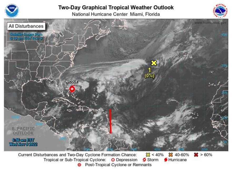
Tropical Storm Nicole: Tropical Storm Nicole is centered near 26.6°N 75.7°W at or 80 nm E of Great Abaco Island moving WSW at 11 kt. Estimated minimum central pressure is 985 mb. Maximum sustained winds are near 70 mph with higher gusts. Some strengthening is expected today, and Nicole is forecast to become a hurricane near the northwestern Bahamas and remain a hurricane when it reaches the east coast of Florida tonight. Nicole is expected to weaken while moving across Florida and the southeastern United States Thursday through Friday, and it is likely to become a post-tropical cyclone by Friday night over the Mid-Atlantic States. Convection had been diminishing through the late evening and early overnight hours but has recently started to increase again with banding forming within 45 nm of the cenre. Seas 12 ft or greater extend well into the north-central Atlantic but are fetch limited elsewhere due the proximity of the storm to Florida and the Bahamas. Nicole will bring hurricane conditions and a dangerous storm surge to portions of the northwestern Bahamas today. Hurricane conditions are expected across portions of the coast of southeast and east-central Florida beginning this evening or tonight. A dangerous storm surge is expected along much of the east coast of Florida and portions of coastal Georgia where a storm surge warning is in effect. This system poses no threat to the State of Grenada.
Tropical Disturbance 1: Showery activity remains disorganized in association with an area of low pressure located about 600 miles west-southwest of the westernmost Azores Islands. The low is moving northeastward and is expected to merge with a frontal system later today. There is a low (near 0%) formation chance within 2 to 5 days. This system poses no threat to the State of Grenada.
The Meteorological Service will continue to monitor the progress of these systems and provide updates in a timely manner.
Elsewhere, tropical cyclone formation is not expected. The next update will be issued at 8 pm.
Cécil Mitchell, Duty Forecaster