


For Tropical North Atlantic Ocean, Caribbean Sea and Gulf of Mexico

AREA OF SPECIAL INTEREST: 10° – 20°N AND 45° – 65°W
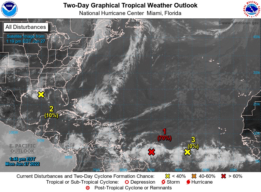
Tropical wave: A tropical wave is located about 765 NM east-southeast of the southern Windward Islands with a weak 1,009 mb low near 08°N 49°W. It is producing scattered moderate and isolated strong convection from 06°N-11°N between 45°W-55°W. Peak winds are near 25 kt and seas up to 10 feet. Environmental conditions appear conducive for further development, and a tropical depression is likely to form during the next couple of days before the system reaches the Windward Islands Tuesday night or possibly while moving westward across the southern Caribbean Sea Wednesday through Friday.
Tropical wave: Another tropical wave is in the central Atlantic with axis along 38°W, approximately 1,389 nautical miles east of Grenada, extending from 01°N to 16°N and moving W around 20 kt. Scattered moderate convection is noted from 05°N-10°N between 38°W-43°W.
Low-Pressure area: Northern Gulf of Mexico: Disorganised showers and thunderstorms over the north-central Gulf of Mexico are associated with a trough of low pressure. Development of this system is expected to be slow to occur while it moves west-southwestward at about 10 mph toward the northwestern Gulf of Mexico and approaches the coasts of southern Texas and northeastern Mexico during the next few days. This system has a low, 10% chance of cyclone formation within the next 48 hours and a low, 20% chance over the next 5 days. This system does not pose a threat to the State of Grenada.
The Meteorological Service will continue to monitor these systems and provide updates in a timely manner.
The next update will be issued at 8 pm.
Kassia Johnson, Duty Forecaster