


For Tropical North Atlantic Ocean, Caribbean Sea and Gulf of Mexico

AREA OF SPECIAL INTEREST: 10 – 20 °N AND 45 – 65 °W
1. Tropical Wave #1
A tropical wave has its axis extending from 07°N to 20°N near 59°W, 160 nautical miles east of Grenada, moving west at 15 kt. Dry Saharan air is limiting convection associated with this wave. 8 JUly 130. Despite the suppression by Saharan dust, models still indicate that the wave will induce an increase in cloudiness, showers, and a medium chance of isolated thunder during the night. Further, a moisture plume at the tail of this wave, will support showery activity on Saturday.
2. Tropical Wave #2
A tropical wave extends from 07°N to 20°N with axis along 42°W, 1160 nautical miles east of Grenada, moving W around 15 kt. Scattered moderate convection is seen where the wave meets the ITCZ, particularly from 08°N to 10°N between 42°W and 45°W. African dust surrounds most of the wave axis at this time.
The Meteorological Service will continue to monitor the progress of these waves and provide updates in a timely manner.
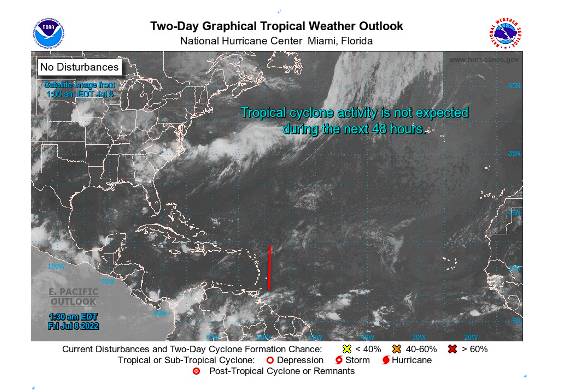
Elsewhere, tropical cyclone formation is not expected during the next 2 days.
The next update will be issued at 8 am.
Johnathan Pryce, Duty Forecaster